
EcoAdapt Case Study Areas
A focus on Vanuatu
Vanuatu
The Democratic Republic of Vanuatu is located in the south-western Pacific Ocean, about 1,750 kilometres east of Australia and 500 kilometres north-east of New Caledonia. It is a Y-shaped archipelago of volcanic origin, comprised of approximately 83 islands (65 of them inhabited) and covering an area of approximately 1.4 million hectare that stretches 1300km with 2,528 km of coastline is mostly rocky, with fringing reefs and no continental shelf. Most of the islands are steep, with unstable soils and little permanent fresh water. It is classified as a SIDSSIDS Small Island Developing States are a distinct group of 38 UN Member States and 20 Non-UN Members/Associate Members of United Nations regional commissions that face unique social, economic and environmental vulnerabilities..
Administratively, Vanuatu is divided into six provinces. The provinces from the largest to smallest are: Sanma, Malampa, Tafea, Shefa, Penama and Torba. Shefa province contains the island of Efate, in which the capital Port Vila is located.
With a relatively small (272,459) and rural (75% live in rural areas) population, Vanuatu is typical of Melanesian countries that rely primarily on subsistence farming for their livelihood. Small-scale subsistence farming is undertaken by 98% of the rural population in Vanuatu and 88% of households are engaged in vegetable crop production. The remaining 25% of the population live in urban areas, with the capital, Port Vila, on the island of Efate housing 51,437. The high population concentration in rural areas poses challenges for service delivery as well as consequences for food security, climate adaptation and disaster recovery and risk reduction strategies.
With the first Category 5 cyclone to hit the region occurring in 2015 (Tropical Cyclone Pam), followed by a second in 2020 (Tropical Cyclone Harold), climate change impacts are very real for residents of the Pacific.
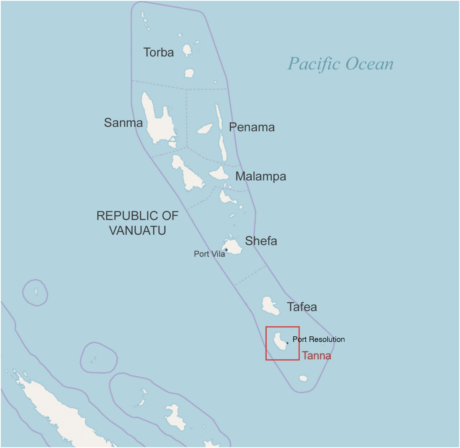
Above: Map of the Republic of Vanuatu, showing the location of Port Vila, Tanna, and Port Resolution.
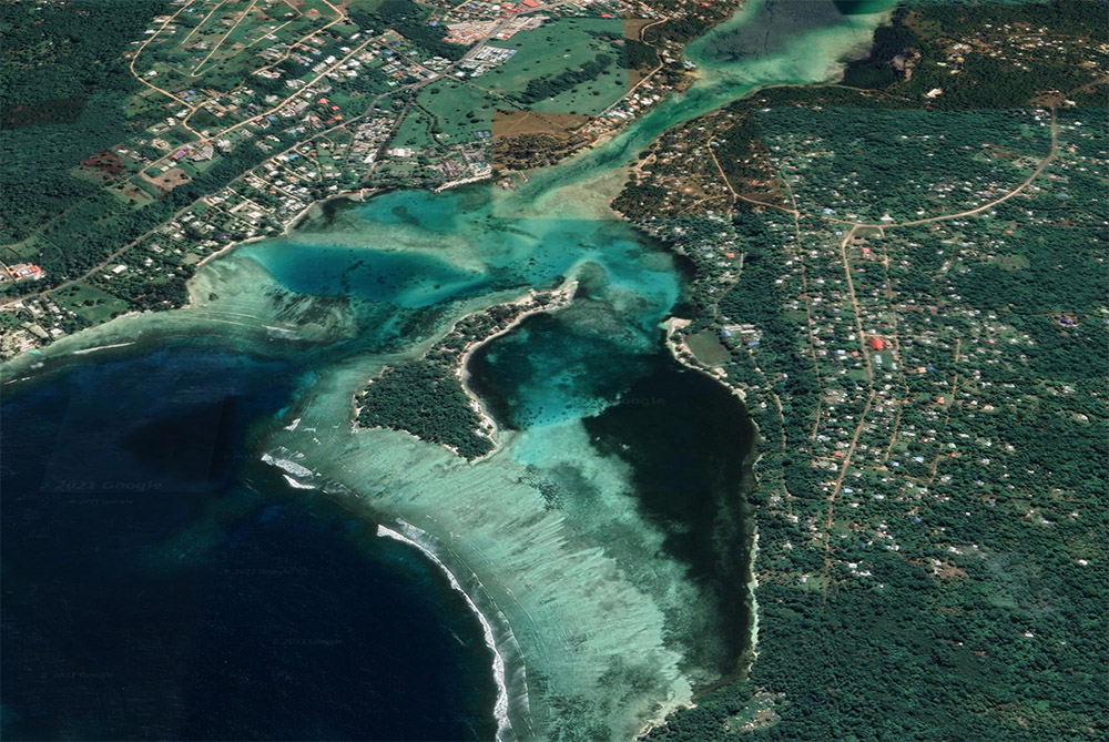
Above: Erakor Lagoon, in Port Vila, Efatee.
Port Vila Bay, Efate
Port Vila Bay is the site of the capital of Vanuatu located on the Southwestern coast of Efate Island. This area was selected as a case study due to the high vulnerability to coastal hazards. The population growth rate on Efate Island is almost double the national rate, with the majority of the growth occurring in the peri-urban fringes of Port Vila municipality, Efate. This population growth has added to the settlement’s concentration within the coastal zone, and together with the high reliance of marine resources for livelihoods and food security and the exposure to coastal hazards such as tropical cyclones and impacts of climate change, this region is highly vulnerable to coastal hazards.
Pollution of coastal recreational waters in small island developing states are also among coastal risks that need attention. Coastal waters are often degraded due to wastewater discharge or runoff contaminated with fertilizer, oil, pesticides, dirt, bacteria and other pollutants from waste disposal as it makes its way through storm drains.
In July 2018, recreational uses of waters in Vila Bay were banned due to contamination with Escherichia coli (E. coli), a potential health threat. This was also suspected for Erakor Lagoon, however, it was not monitored. As the coastal water in Erakor lagoon system is widely used by the local communities and tourists for snorkelling, fishing and swimming, understanding the residence time of any pollutants discharged in the lagoon is important to maintaining water quality and for the health of the local population.
Erakor Lagoon also hosts current and future tourism facilities along its shore. In this case, coastal adaptations to protect the population bordering the lagoon rely more on soft or hard engineering solutions than evacuating the risk zones as it could be in a low development zone such as Port Resolution in Tanna. Moreover natural ecosystem has already been modified and this is another aspect to treat when determining adaptation strategies.
The Southwest of Efate was also a practical case study site in that data collection was more accessible than for remote locations and allowed study of the reef processes in detail. Once methods to estimate risks in reef environment were established transferral of this approach to other locations could be facilitated for future studies.
Tanna
Tanna Island is a volcanic island in the southern province of Tafea and covers an area of 58,793 hectares. In 2016 there were 32,280 people living on Tanna, although current estimates are likely higher, given rapid population growth. For example, during government recovery and food relief operations after 2015 Tropical Cyclone Pam, 44,000 people were reported as residing on the Island.
Seven different indigenous languages are spoken on Tanna, with some also speaking Bislama, one of the official languages of Vanuatu. Many of the tribes on Tanna live in traditional housing and have a long history of coping with cyclones. Tanna is often referred to as the stronghold of kastomkastom Kastom is a pidgin word (Bislama/English) used to refer to traditional culture, including religion, economics, art and magic in Melanesia. The word derives from the Australian English pronunciation of 'custom'. Kastom is mostly not written, only passed down through teachings and stories and includes places, stories, objects and animals and plants.; a place where people still know traditional songs, can trace their lineage, and still participate and organise kastom rituals and ceremonies. Tanna is regarded as an example of how kastom and modernity coexist hand in hand.
Tanna’s system of governance is a hybrid system, with formal institutions of representative democracy and the administrative state, combined with the integration of traditional structures (the Malvatu Mauri, or National Council of Chiefs, which advises on issues of culture and language), under-written by constitutional ecognition, and village level decision-making through the Nakamal, the traditional meeting place.
One of the areas on Tanna with the lowest elevation is the shallow bay of Port Resolution on the east of Tanna Island, where a small village of approximately 500 people from four different tribes is situated above the bay.
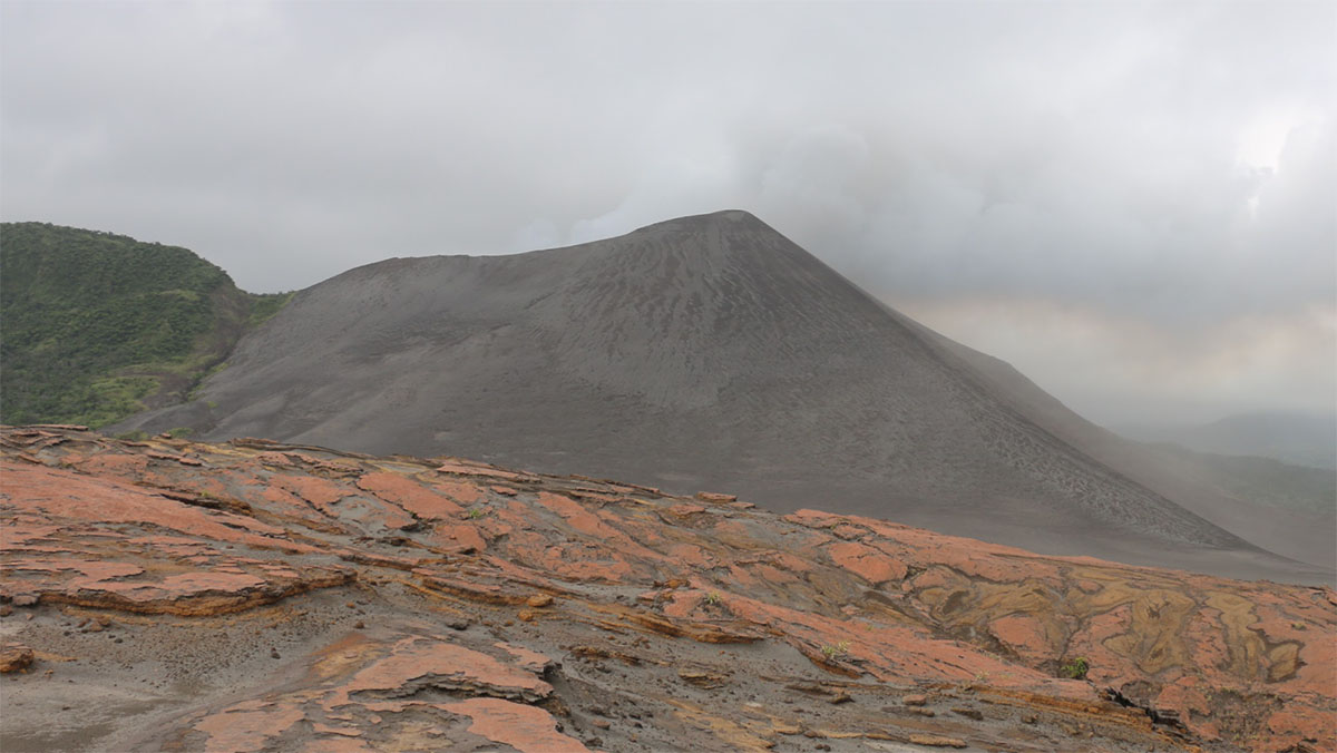
Above: Yasur volcano on Tanna is the island's leading tourism destination
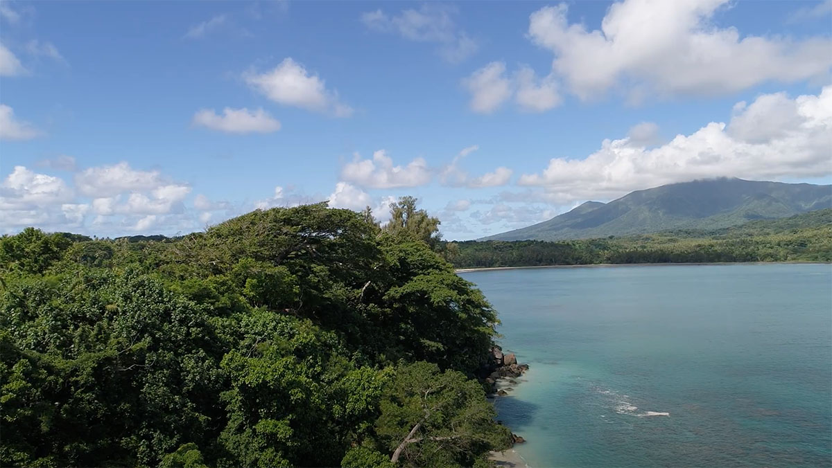
Above: Port Resolution is a community in the south east of Tanna. Though still low-key, it is growing in popularity with tourists due to its natural assets.
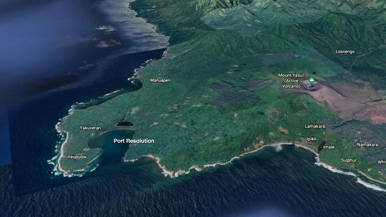
Above: Port Resolution and nearby destinations, such as the Yasur volcano.
Port Resolution
Port Resolution is a series of small hamlets in the south eastern corner of Tanna. The community comprises approximately 280 ha of land and 150 ha of inshore coastal coral reef and in-shore lagoon. The population largely lives in traditional housing, is agrarian subsistence-based, and retains strong familial and tribal affiliations. Tanna is often referred to as the stronghold of kastom1 – a place where people still know and revere traditional songs, can trace their lineage, and organise and participate in rituals, community decision-making processes and ceremonies. Tanna is commonly regarded as an example of a location in which kastom and modernity can coexist.
The Port Resolution community depends almost exclusively on a combination of subsistence farming, animal husbandry, and artisanal fishing for sustenance and non-food product harvesting for building dwellings. Customary resource management practices rely on the ability of resource users to adaptively manage and understand generally tight biophysical feedback loops, and to effectively modify community-wide practices accordingly. These customary practices are generally built on a foundation of manipulating or supporting ecological processes. The Port Resolution farming system typically comprises three components:
- a shifting cultivation system;
- a perennial plantation cultivation system; and
- a forest and arboricultural system.
The productivity of this subsistence system and integrity of the adjoining tropical forests are at the centre of a complex web of interdependencies that have an impact on overall village community well-being and resilience to climate change. This productivity is reportedly under threat, mostly likely from shortened fallow times in the shifting cultivation system. As with the land, the inshore marine areas are subject to customary ownership and allocation of access, and are both economically and culturally important to the Port Resolution community.
Marine habitats in the Port Resolution area include significant areas of shallow coral gardens and sea grass beds in some of the more sheltered areas on the lee-side of the reefs. Customary marine fisheries management has evolved to manage social relationships (closures for funerary rights, or managing relations with neighbours), rather than from a need to conserve fisheries.
There are no permanent freshwater streams in Port Resolution. The village's water source is a single mains pipe, which runs a significant distance (~10 km) from a nearby mountain range. The flow from this source is slow but is consistent and reportedly rarely fails completely. In the main village (Ireupuow) there is a groundwater pump, which at the time of our field work was broken. A limited number of rooftop capture water tank combinations have been installed.
Ecosystem-based adaptation
Ecosystem-based adaptation is an approach where ecosystems and livelihoods mutually support adaptation.
Climate risks
Climate change impacts are increasing in frequency and intensity and threaten to affect the integrity of, and even irreversibly change many ecosystems and the multitude of functions and services provided to humans, challenging the security and wellbeing of current and future generations.
Case study locations
About our case study sites: the Pacific, Vanuatu, Tanna island, Port Vila, and Port Resolution.