Coastal processes

Port Resolution

Understanding coastal processes

Understanding the processes and interactions in the coastal zone in Pacific SIDSSIDS Small Island Developing States are a distinct group of 38 UN Member States and 20 Non-UN Members/Associate Members of United Nations regional commissions that face unique social, economic and environmental vulnerabilities. is critical to assessing current and future risks from climate change. Larger scale ocean currents interact with coastal and inshore features such as reefs, rocky shores and beaches to uniquely shape the landscape. By understanding how these processes work at different scales, and then overlaying projected scenarios of climate change, communities, planners and other decision-makers can be more informed about the options available to them in adapting to climate change in their local areas.

Identifying climate risks and hazards

Firstly it is necessary to understand the existing hazards and risks for the coastal zone and how these might be exacerbated under different climate change scenarios.  Table 1 below shows identified climate risks for the case study area of Tanna Island, Vanuatu including water quality and nutrient runoff, erosion from storm events, ocean acidification, sea-level rise, and development pressures around the coastal zone.

Table 1: Summary of risk identification for the fringing coral reef socio-ecological system for Vanuatu and Tanna
HazardHazard indicatorMappingImpactsVulnerabilityExposure
Increase in nutrients entering coastal watersWater quality from adjacent catchmentCatchment population densityAlgal blooms and reduced sunlight.
Crown of thorns starfish population increases and kills coral
Lack of alternative food supply; competition from growing tourist demand for seafood; lack of formal, or breakdown in customary reef management; customary connection to placeLocation of reef relative to densely populated areas
Over-harvesting of grazing fishPopulation pressure on reefArea of reef per person from the local areaAlgal growth covers and kills coralsCommunities with the lowest area of reef per person are most exposed
Erosion damage during storm eventsProportion of community lands prone to erosionArea of unstable shoreline as a proportion of community landsLoss of assets, loss of land which increases pressure on remaining landCommunities with the largest proportion of lands in areas of shoreline stability are most exposed
Ocean acidificationpH level of waterThere are no currently available data to show variation around Vanuatu and TannaCauses breakdown of the coral structuresAll of Vanuatu and Tanna
Sea level riseSea surface temperatureThere are no currently available data to show variation around Vanuatu and TannaReduces UV radiationDepth of reef
Capital worksProjection of future demand for tourism developmentsTourism development potential and local tourism attractionsTourism development damages coral reef or alters coastal systemLocation relative to tourism development

This figure shows the identified risks and hazards mapped to the Tanna island coastal zone across four risk levels - low through to extreme. See the ESRAM Final Report for detailed results.


Fringing coral reef analysis for Tanna Island showing four risk indicators mapped in four categories of low to extreme

Building a knowledge base for understanding coastal processes

Local variability of ecosystems and interactions between them and global systems such as the hydrological cycle, ocean currents and temperature are necessary to take into consideration when identifying current and future climate risks and hazards and therefore in identifying appropriate responses. But assessing coastal hazards in the South Pacific is challenging as limited local scale data is accessible. To better understand both present-day and future conditions in the marine environment and the coastal zone, Griffith University researchers conducted ecosystem assessments at both the national scale (Vanuatu) and island scale (Tanna).

One of the challenges Pacific SIDs face when trying to develop adaptation and mitigation strategies to limit the impact of sea level rise and climate change on coastal communities, is a lack of understanding regarding the variability of sea level and sea temperature. Satellite observations and global ocean models can provide data, however their coarse spatial and temporal resolution are unable to predict how the ocean processes influence water levels, currents, and water temperatures within coastal waterways and at island shorelines. As a consequence, there is a gap in our understanding of how climate change will impact SIDS at the scales necessary to make informed land and marine management decisions.

As part of the EcoAdapt project this gap in understanding was addressed by developing a regional ocean model capable of replicating the behaviour of complex jets and currents in the deep ocean, to allow modelling high-resolution near-coast tidal circulation including sea level variability around individual islands. Simulations were also run to identify areas where currents will alter under different predicted sea levels and wind velocities expected under different climate change scenarios.

Results from numerical experiments show that ocean processes driven by the complex regional circulation, significantly affect coastal water levels in this oceanographically dynamic region. That is, the position of high water, which affects a location's exposure to coastal hazards such as high wave events and storm surge, shifts in response to the presence of jets and currents flowing in deep water.

The information produced in this model is vital in understanding how changes in ocean processes will increase or decrease the vulnerability of a site to both coastal hazards and future sea levels.

Above: Ocean circulation model around the Pacific islands of Vanuatu.

Local study sites were selected for higher resolution investigations focussing on coastal hazards: Port Resolution in the south-east of Tanna Island, and Mele Bay and Erakor Lagoon on Efate Island. These sites all face increased exposure to coastal hazards under future climate conditions, however the principal hazards affecting the sites differ. In this way we gain a more representative understanding of the different threats faced by coastal communities across the region. New numerical modelling tools were created to better replicate coastal circulation at specific study sites, as well as across the Vanuatu region more broadly. Field campaigns were undertaken, to provide valuable site-specific data to verify modelling efforts, in addition to providing baseline information describing water quality and marine ecosystem health.

The studies under this theme have improved knowledge of circulation within coral reef lagoons and helped to better understand the implications for water quality of waste water management as a critical threat to coral reef ecosystems.

Key findings and recommendations from the coastal processes studies

The following activities should be undertaken to support EbAEbA Ecosystem-based adaptation - an adaptation approach to climate- and environmental-change which primarily deploys ecosystems and ecosystem functions to mitigate risks from hazards. at the local and regional level:

  • A program of data collection in Pacific SIDS to support understanding coastal processes. Permanent wave buoys should be deployed across the islands to complement the wave hindcast developed as part of Australian Aid funded Pacific‐Australia Climate Change Science and Adaptation Planning Program (PACCSAP). The wave buoy data is essential to validate the wave hindcast model and to then be used for wave climate projections.
  • Data collection should always involve local residents to build local capacity and knowledge, but also to support care and protection of any measurement equipment.
  • Development of fine numerical models to understand local processes where possible and develop a strategy of adaptation
  • Enhancement and protection of natural defences to reduce coastal risks. Encouraging communities to work with nature and prevent activities that could damage the natural defences like dredging a reef, removing vegetation or sand. Provide local trainings and community engagement by sharing knowledge on coastal adaptations.

In Port Resolution:

  • Implement regular surveys of the cliff and uplifting. The measures need to use the same reference point to measure sea level variations. Monitoring that includes regular updating of the satellite altimetry including vertical land motion assessments based on both altimetry and the tide-gauge data  (ALT-TG) estimates and any continuous GPS . Bathymetry and Topography need to be measured on a regular basis particularly in Tanna where the uplifting rate is relatively high.
  • Stabilise the cliff with vegetation and discuss options with the community for potential relocation of the school on the top of the cliff due to the high instability

In Erakor lagoon:

  • Continue a long-term program of monitoring in partnership with the Water Department, with the ultimate aim to improve water quality indicators

Publications and resources related to coastal processes

Erakor lagoon, Efate

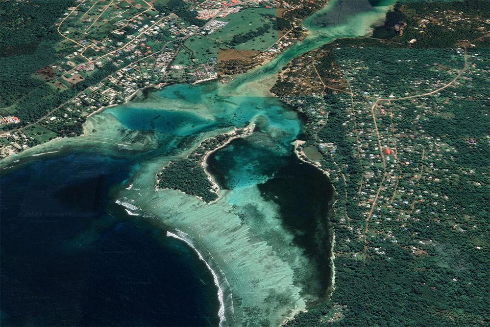
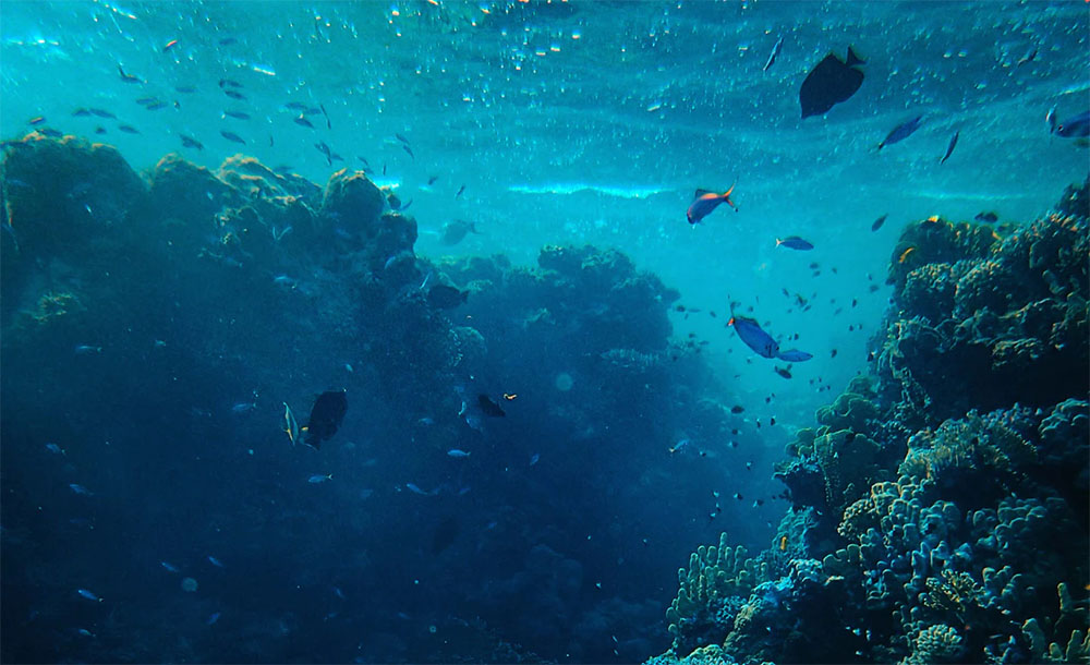
Water quality in coral reef lagoon system

Coastal waters are used for recreational activities such as swimming or fishing. In the South Pacific Islands, most of the population and infrastructures are concentrated near the coast. Wastewater discharge are often not well regulated and released in the coastal waters. Growing population and effect of climate change might compromised the water quality of coastal lagoon if no management plans are established.
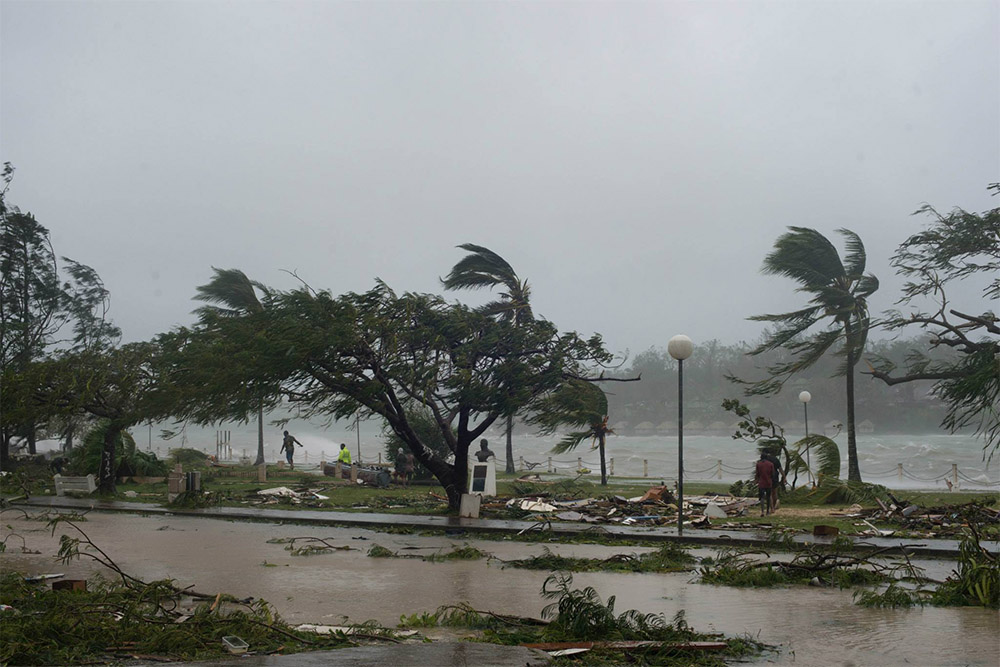
Coral reef in Vanuatu

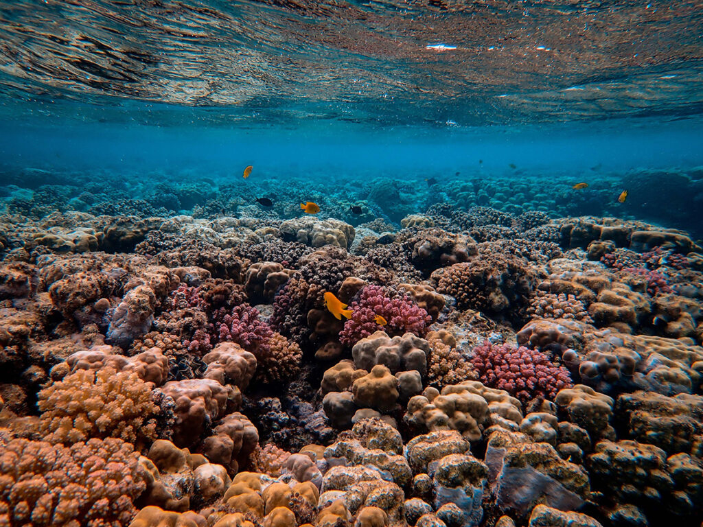
Climate change adaptation strategies for coral reef ecosystems

This paper reports on a dynamic modelling framework for ecosystem-based adaptation planning in a SIDS island context that is focussed on the assessment of coral reef health and resilience under different climate change scenarios, and the consequential economic and human well-being impacts. Port Resolution, Tanna Island was used as a case study to develop, test and model the fringing coral reef, local community and resultant socio-ecological system.
Citizen science

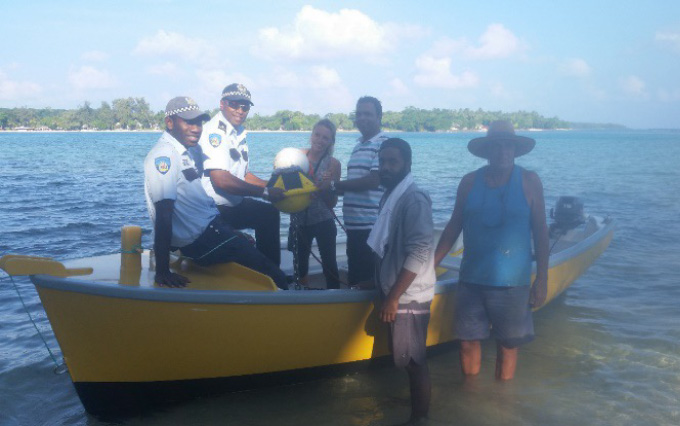
Data collection and unexpected events

This paper is a story of our field data collection in Efate Island illustrating all the challenges and unexpected events. This data collection campaign was a great experience and has allowed to establish good connection with the local government, the University and local communities. The involvement of the local communities was found crucial to lead this monitoring campaign.
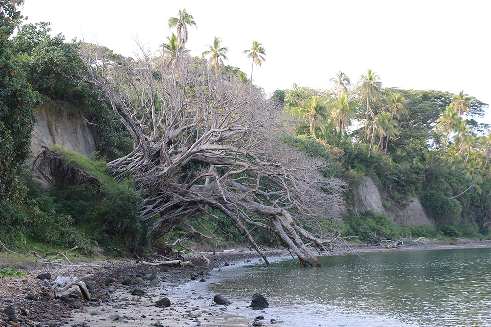
Port Resolution

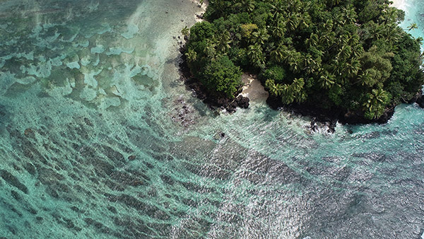
Predicting sea-level rise induced coastal erosion in Tanna Island

Anticipated sea level rise in coastal regions is expected to worsen the impact of coastal hazards such as erosion, inundation and flooding from storm surges. Accordingly, the resulting impacts on coastal settlements and infrastructure will be widespread. These impacts are particularly critical in small islands as the settlements and infrastructure are mainly located along coastlines with almost no, or very limited relocation options.
Cyclone Pam

What constrains ecosystem-based adaptation?

While ecosystem-based adaptation is a popular approach to managing climate change risks, uptake is still low. This paper explores the constraints and barriers around the adoption of ecosystem-based adaptation and seeks to enable practitioners and academics a pathway to embrace all of the dimensions involved to increase uptake and success.
Sea wall construction in Tanna

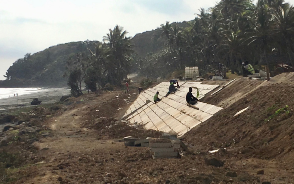
How we protect buildings and communities from sea level rise due to global warming

Currently, the standard approach to defending buildings and other structures from the rising sea level impacts is through construction of a concrete or rock seawall, or some similar kind of so-called “capital works”. However, these interventions destroy or degrade natural ecosystems. One solution that avoids this problem is to use ecosystems to help reduce the risks from increasing coastal inundation and erosion.

Pacific EcoAdapt